
Henderson Block Sources
A block search is strongest when it distinguishes parcels, owners, and people who may be present. The City map can identify touching parcels and show the legal and neighborhood layers around an address. The Assessor provides the owner of record, situs, and tax mailing address for a parcel, while the Recorder can show a recorded transfer or lien trail. A voter product is limited to data lawfully released for registered voters. Association and civic sources can identify a public contact route or a community boundary. None of those sources makes a complete household list.
| Source | What It Shows About a Block | Access |
|---|---|---|
| Henderson GIS parcel layer | Touching parcels, APNs, and city, ZIP, HOA, ward, and zoning context | Public map; search then click or identify |
| Clark County Open Web | County parcel, Assessor, imagery, planning, and administrative layers | Public map; query and export options vary |
| Clark County Assessor | Owner and mailing or situs information for each parcel | Public search; no household guarantee |
| Clark County Recorder | Recorded transfers and liens tied to an adjacent APN | Index from 1988; microfilm from 1909; copies are paid |
| Voter walking list | Registered-voter product by precinct, district, and status | Request or download under applicable rules |
| HOA map and liaison layer | Master or sub-association coverage and liaison geography | Public GIS; not a member directory |
For a block search, record the address and date beside each result. An owner can receive tax mail elsewhere, and a recorded deed names parties to an instrument rather than every person at a parcel. The public map is the geometry layer. The county records are the ownership and document layers. That division prevents a map label or a mailing line from being mistaken for proof that someone lives there.
Map a Henderson Block
The adjacent-parcel process begins with the exact address in Henderson My Neighborhood or Clark County Open Web. Confirm the selected feature's street, jurisdiction, and ZIP rather than trusting a postal-city line. A cul-de-sac, corner lot, alley, or HOA common area can touch a target parcel without being another household. Call it an adjacent parcel unless a public record says more. Keep the map date and disclaimer with the APN notes, because parcel layers are useful for navigation and context, not a title survey.
- Enter the exact address, center the map, and confirm the selected street, jurisdiction, and ZIP.
- Activate the parcel or Assessor layer and capture the target APN and legal subdivision or lot-block information if displayed.
- Pan and zoom at the same scale to identify each polygon that physically touches the target parcel.
- Take each adjacent APN to the Clark County Assessor, using owner and prior-owner modes where relevant.
- Use the Recorder APN search for the parcel's recorded history and map layers for the block's jurisdiction and association context.
Note: An adjacent parcel can be a common area, an alley, or a corner lot, so adjacency is a map fact rather than proof of a personal relationship.
Henderson Parcel Map Layers
My Neighborhood accepts an address in the Search Here field, such as the Water Street example shown on the public interface. After the map centers, use Base Map for reference and turn on the layers that answer a geographic question. The public map includes Business License, Council Ward, HOA, Jurisdiction, Parks and Trails, Planned Land Use or Zoning, School or Attendance Zones, Seismic, Trash Day, Watering Group, and ZIP. The City GIS hub also lists printable street-address maps and downloadable data. These controls explain a block's public context, but the owner name belongs in the linked county record.
- Search Here and Find
- Center the address before selecting a parcel or turning on a layer.
- HOA and Neighborhood Liaisons
- Identify association coverage and public liaison geography.
- Jurisdiction and Council Ward
- Check city or county context and local ward boundary.
- ZIP, Zoning, and Planned Land Use
- Separate postal, planning, and legal-boundary context.
- Schools, Parks, Trails, Watering Group, and Trash Day
- Describe public service and neighborhood context without identifying residents.
- Make a reference map after checking the visible layer and date.
The assigned Henderson My Neighborhood screen shows the address-search environment used for this block workflow, including its parcel and neighborhood context.
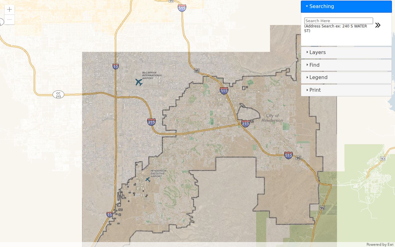
Use the map to identify an APN and nearby boundaries, then confirm ownership or document history through the appropriate Clark County source.
Henderson Deed Checks
The Recorder does not use a street address as its central identifier. Translate an address into the 11-digit APN or legal description with the Assessor, then search AcclaimWeb by Parcel #. Its Parcel search allows an APN with Starts With, Contains, or Exact matching, plus date-range and document-type limits. The Recorder's other modes include Name, Instrument #, Book/Page, Record Date, Total Value, and Legal Description. If an APN has changed, carry forward the legal description, recorded plat, subdivision lot and block, and parent parcel.
For each adjacent APN, note the instrument number, recording date, document type, and indexed grantor or grantee. A newer owner's acquisition deed often names that owner as grantee. The prior grantor can lead to an earlier deed, but joint owners, trusts, limited liability companies, misspellings, trustee deeds, deeds upon death, reconveyances, and foreclosure notices all need their own context. The online Official Records index begins in 1988. For earlier material, use Recorder microfilm or office research beginning in 1909. Public index images are not directly viewable; order only the needed copy or use the counter or mail route.
Henderson Voter Boundaries
Clark County's public voter channel is a file or walking-list product by precinct or district, not a guaranteed block roster. The Registered Voter Services route is login-based for a voter to view personal registration and voting information. Public data can contain name, status, party, precinct, district or ward, registration date, and address information as Nevada law permits. It does not reveal ballot choices, full dates of birth, Social Security numbers, driver's-license numbers, or protected-address data. A voter-product absence is not proof that a person does not live on the block.
- Weekly Active or All file: Organized by county or district; inactive means the address is not current in the registration system.
- Walking list: A precinct-based product, not a universal map of every household.
- Custom request: State the precinct, election cycle, status, format, and lawful civic or research purpose.
- Personal voter service: Requires the voter's own login and is not an open name search.
The county's Election and Voter Information sheet lists standard file and custom report formats. It also explains that public products change over time. In 2026, a Nevada Attorney General announcement concerning unredacted rolls made the same distinction plain: the public data product is not the protected administrative database.
Henderson Association Geography
The HOA layer in Henderson My Neighborhood works with Master HOA, HOA, Neighborhood Liaisons, and Wards geography. An association polygon answers which association covers a parcel. It can also provide a map label or public liaison geography. It does not publish a member list. Query the dynamic legend for the current neighborhood name because boundaries and associations are more precise than broad neighborhood labels such as Green Valley or West Henderson.
| Association shown in GIS legend | Useful public context |
|---|---|
| Anthem Community Council | Association coverage for an Anthem-area parcel |
| Green Valley Ranch Community Association | Master or community boundary context |
| Inspirada Community Association | Parcel-to-association geography in southern Henderson |
| Lake Las Vegas Master Association | Master-association context near the eastern community |
| Sun City MacDonald Ranch Community Association | Named association geography for a selected parcel |
| Westwood Village Neighborhood | Neighborhood layer context rather than a household list |
Public meeting notices, governing documents, a registered-agent filing, and a public management contact can be useful next steps. Nevada's Real Estate Division and Ombudsman's Office for Owners in Common-Interest Communities and Condominium Hotels handles HOA enforcement. Association participation still follows the association's own board or management process.
Henderson Community Contact Routes
Community sources can explain a block without turning it into a private directory. Henderson Neighborhood Services, block-party and block-captain materials, public church or congregation notices, Chamber listings, school or park program announcements, and civic clubs can identify organizations and public contact people. The Henderson Libraries Digital Archives and Henderson Home News add historical meeting notices, anniversaries, club mentions, and organizational addresses. Use a public organization contact to learn about a program or association, not to infer who is present at every nearby parcel.
- Check Neighborhood Services for a civic contact path or neighborhood program.
- Use a map's HOA and liaison layers to confirm association geography before contacting a public office.
- Search local newspaper and library archives for a congregation, club, school, or event name connected to the block.
- Verify a business or organization through public filings when a listed community contact needs confirmation.
Note: Public organization listings describe a group or event; they do not identify every person who lives nearby.
Block Tool Comparison
Official sources and commercial lookup tools answer different questions. A county or city record names the custodian, record type, date, and access limit. A commercial category may combine public records, purchased data, marketing data, and user-supplied material. That can create stale address matches, duplicated entries, and same-name errors. A paid compilation is not a certified government record. Use the original Assessor, Recorder, court, elections, or association source to verify a meaningful result.
| Official map or record | Commercial lookup category |
|---|---|
| Shows source, custodian, date, and record-specific limits | May combine data from different dates and sources |
| Separates parcel owner, deed party, voter product, and association geography | Can conflate owners, former contacts, and people with similar names |
| Supports a direct request or correction with the responsible office | May offer a privacy request, but that does not erase government records |
A mismatch should send the search back to the dated public record and the correct custodian. Nevada's data-broker opt-out rule can address covered information sold by a broker, but it does not remove the county's recorded deed, parcel, or court file.
Note: A document date and custodian matter more than a compiled label or an unverified address match.
Henderson Block Privacy
Parcel records identify owners, not every occupant. Voter products identify only registered voters whose information is lawfully released. HOA layers identify association geography, not members. Recorded deeds identify instrument parties, while permits can identify public applicants or contractors without describing the people at an address. DMV, utility, delivery, and service-customer records remain restricted. Nevada's Confidential Address Program, sealed matters, family files, and juvenile files can create deliberate gaps. Those limits protect people and improve the accuracy of a block search.
For the wider record chain along a named road, use the Henderson street address directory after the immediate block has been mapped. Keep owner mailing lines separate from situs addresses, do not publish more than the public record shows, and ask the custodian about a specific correction or access rule rather than filling gaps with assumptions.
Privacy and lawful use. Block research can support civic curiosity, family connections, or a records correction. Never use public details to monitor, stalk, harass, intimidate, or harm another person.