
Henderson ZIP Code Directory Coverage
Postal geography around Henderson is broader than the legal city footprint. The Clark County ZIP-boundary map, dated November 22, 2025, overlays ZIP polygons and city limits. Its labels and the City's ZIP appendix identify ZIPs inside, beside, or used around Henderson. The table separates documented area descriptions from postal claims that the research could not verify. A polygon can support a map search, but it cannot replace final address validation.
| ZIP code | Areas or communities in local map material | Postal note | Boundary and search note |
|---|---|---|---|
| 89002 | Southeast Henderson, Boulder Highway, Horizon Ridge, foothill and southern areas | Henderson postal route; station name not identified | Check city, county, and annexation edges by address |
| 89011 | East Henderson, Lake Las Vegas, Galleria, and east-of-Water-Street area | Henderson postal route | Map overlay is needed near city-limit and unincorporated edges |
| 89012 | Central/east Henderson near Green Valley, Horizon Ridge, and Black Mountain | Henderson postal route | Postal city does not set the Assessor City/Town field |
| 89014 | Green Valley and east-central Henderson | Henderson postal route | Assessor search is not primarily ZIP-wide |
| 89015 | Historic Henderson, Water Street, and central neighborhoods | Henderson postal route | Original-townsite context and older street grid |
| 89044 | Southern/west Henderson, including Inspirada and Anthem-area growth | Henderson postal route | Subdivision and annexation chronology matter |
| 89052 | Southern Henderson, Anthem, Seven Hills, and West Henderson vicinity | Henderson postal route | City line and association layers can help |
| 89054 | Southern/east-southern Henderson edge | Henderson postal route | Confirm the individual parcel and jurisdiction |
| 89074 | Green Valley Ranch, Green Valley South, and southeast developed areas | Henderson postal route | Neighborhood match is approximate, not a legal boundary |
| 89077 | Henderson postal designation in county-map context | Exact delivery use not located | Research gap: verify classification with USPS |
| 89009 | Henderson postal designation | PO Box or general-delivery style use is likely; station detail not located | Do not use as situs geography without street validation |
| 89120 | Las Vegas/Henderson boundary area in the southeast valley | Las Vegas postal city can reach the Henderson side | Direct city and ZIP mismatch is possible |
| 89121 | Southeast Las Vegas and Henderson edge | Las Vegas postal city | County map shows edge overlap |
| 89122 | Southeast valley, Pittman, and county/Henderson edge | Las Vegas postal route | City Pittman map labels it; use as boundary context only |
| 89123 | Southeast valley near the Henderson/Las Vegas edge | Las Vegas postal route | Confirm city limits instead of inferring from ZIP |
| 89124 | Countywide map label near the Henderson side, not ordinary city core | Las Vegas postal route or special geography | Research gap: USPS street validation needed |
| 89183 | South Las Vegas and West Henderson edge | Las Vegas postal route | Can appear in regional searching; confirm city limits |
The Henderson ZIP code directory is a map of candidate postal areas, not a promise that every street in a listed ZIP lies in the city. Research did not locate an official USPS downloadable list of every post-office name serving legal Henderson. That gap is intentional in the table: unknown station labels are not guessed.
Henderson 89015 ZIP History
ZIP 89015 is the historic Henderson and Water Street area in the local map material. The city grew from the Basic Magnesium townsite: construction began in 1941, townsite work followed in 1942, the post office was established in 1944, and the townsite became Henderson that January. The city incorporated in 1953, when its original footprint was far smaller than today. These dates help explain why older address research often starts with maps, plats, or a newspaper rather than a modern subdivision name.
Water Street preserves the industrial pipeline story. For a mid-century address that does not fit a current map, the documented 1955 Pioneer Title cadastral map has a street index. It is a cadastral map, not a proof of occupancy, but it is a useful bridge between older street labels and current parcel geography.
Southern Henderson ZIP Areas
The southern and planned-community pattern is different from the townsite pattern. Local materials place 89044 around southern/west Henderson and Inspirada or Anthem-area growth; 89052 around Anthem, Seven Hills, and West Henderson; 89054 at a southern edge; and 89074 around Green Valley Ranch and Green Valley South. The area labels are useful starting points, not address-level boundary decisions. Green Valley, Anthem, Inspirada, Lake Las Vegas, and West Henderson are neighborhood or development references that can overlap ZIP, HOA, and jurisdiction layers differently.
Later planned areas may first appear in plats, permits, HOA maps, and Assessor subdivision searches. The City's GIS service is useful for the geographical question, and the Assessor record is the right next step for the parcel question. Note: A community name can describe a neighborhood without establishing a municipality or postal delivery area.
Search Henderson ZIP Map Areas
A ZIP polygon narrows geography, not people. Henderson My Neighborhood has address search and a ZIP Code layer; Clark County GIS offers a ZIP layer that supports queries, pagination, statistics, and service-level export. The Assessor's documented modes are parcel, owner, address, subdivision, subdivision owners, book/page, parcel tree, and map inquiry. It does not expose a public ZIP-wide result mode. Voter products are organized by county, district, precinct, party, and status, and the published sheet does not promise ZIP filtering.
- Search the exact address in Henderson My Neighborhood, then turn on ZIP and Jurisdiction context.
- Use the City or County map to inspect the ZIP polygon and select the parcel that actually contains the address.
- Capture the parcel's APN and use the Assessor by APN or address to read legal City/Town, situs, and property facts.
- Use the Recorder only after the APN or legal description identifies the parcel. Its recorded-document index is not a ZIP search.
- Finish with the USPS address and ZIP lookup for current delivery validation.
Once a polygon leads to a named street, the Henderson street directory supplies the address-to-parcel and deed workflow. Do not treat a map match as a resident list or a legal title conclusion.
Henderson Parcel Searches After ZIP
Use ZIP geography to select a parcel, then switch to the custodian that maintains the type of record needed. The available functions are uneven by design. Maps locate a polygon. The Assessor identifies assessment and property data. The Recorder indexes instruments by APN and legal description. Elections data has its own controlled product structure. The following capability table records only the public functions documented in the research.
| Service | Documented search capability | What ZIP adds | Limit |
|---|---|---|---|
| Henderson My Neighborhood | Address search with ZIP and jurisdiction layers | Shows postal-polygon context for an address | Not a people list or title survey |
| Clark County GIS | ZIP polygon query, pagination, statistics, and export support | Shows parcel or address intersections | Map geometry needs parcel confirmation |
| Clark County Assessor | Parcel, owner, address, subdivision, book/page, parcel tree, and map inquiry | Use after map selection to identify APN | No public ZIP-wide mode exposed |
| Clark County Elections | County, district, party, precinct, and status products | A custom request may be discussed with Elections | Published sheet does not promise ZIP filtering |
| USPS lookup | Street-address and ZIP validation | Final delivery check | Does not determine municipal boundary |
The Clark County Assessor Real Property Records page lists the assessment search modes used after the map-to-parcel step.
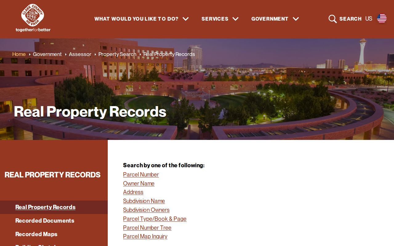
The illustrated menu confirms why an address or APN is needed after ZIP geography has narrowed the area. A ZIP alone is not the Assessor's primary search key.
Henderson ZIP Code City Limits
A Henderson postal line does not establish a legal city boundary. The County Assessor separates a parcel's situs from the owner's tax mailing line and defines City/Town as legal parcel geography. The local map shows Las Vegas postal routes around Henderson edges, including 89120, 89121, 89122, 89123, 89124, and 89183 context. Conversely, a Henderson postal route can reach a parcel that needs a city or county check. Use jurisdiction and annexation layers for municipal context, then rely on the parcel, recorded plat, and deed for legal land detail.
- ZIP
- A postal delivery area. It is not a municipal boundary or a parcel identifier.
- ZIP+4
- The extra four digits that refine delivery for a particular address, block, or delivery segment.
- PO Box ZIP
- A postal designation for box or general-delivery use, which should not be treated as a street situs.
- Carrier route
- A mail-delivery grouping used by the postal service, separate from ownership and city-boundary records.
Boundary check. Compare the postal result with the My Neighborhood Jurisdiction layer and the Assessor City/Town field before describing an address as legally inside Henderson.
Henderson ZIP Annexation Checks
Historic location matters because Henderson's legal footprint expanded over time. City GIS lists an Annexations polygon layer with year labels beginning in 1953, then 1954-1959, 1960-1969, and later periods. A record from an earlier period may therefore belong to county geography even when a current postal address says Henderson. The 1953 incorporation proposal covered the original townsite, Pittman, Carver Park, Victory Village, Henderson Townsite Annexes, and Manganese Park, followed quickly by subdivision plats.
Use the dated annexation layer with the 1955 map, City street-address maps, plats, and the Assessor legal description. Research did not find a verified year-specific Henderson renumbering list, so an unexplained historic address should be checked against map indexes rather than assigned a made-up street change.
Henderson ZIP Boundary Limits
ZIP geography has a useful but limited role in local research. It can narrow where to begin, reveal a boundary mismatch, and direct a searcher to the right parcel. It cannot show every occupant, establish an ownership chain, or prove a city boundary. For a current address, preserve the USPS result, the map's ZIP and jurisdiction context, the Assessor's APN and situs fields, and any later Recorder document as separate evidence.
Nevada Public Records Act requests under NRS Chapter 239 remain available for a City record not posted online, subject to redaction and confidentiality rules. Protected addresses and record-specific privacy limits may properly create gaps. Use address information for lawful personal research, family history, estate questions, property curiosity, or civic transparency, never to stalk, harass, intimidate, or harm anyone.